Blog

SMR / RMP / RHM ….. WTF!!!

The legislation

The principal components contained within each act/amendment are listed below.

  • The National Monuments Act 1930
  1. Protects National Monuments
  2. Makes it a legal requirement that people report the discovery of archaeological objects
  3. Restricts export and prohibits injury to archaeological objects
  • The National Monuments (Amendment) Act 1954
  1. Makes it possible for the Commissioners to undertake Preservation Orders and Temporary Preservation Orders
  2. Clearly states that any church, ecclesiastical building or structure vested under the Irish Church Act, 1869, is a National Monument
  • The National Monuments (Amendment) Act 1987
  1. Restricts the use of detection devices
  2. Protects the sites of historic wrecks
  3. Requires the establishment and maintenance of a Register of Historic Monuments
  • The National Monuments (Amendment) Act 1994
  1. Allowance for inspection and excavation by a Director
  2. Requires the establishment and maintenance of a Record of Monuments and Places
  3. The National Monuments (Amendment) Act 2004
  4. For approved road developments, makes it possible for the Minister to demolish National Monuments

You might have noticed that there is no mention of the Sites & Monuments Record (SMR) ……. so what is the SMR? www.archaeology.ie states, “the information in the Archaeological Survey of Ireland (ASI) archive was issued on a county basis between 1984 and 1992 as the Sites and Monuments Record (SMR).” This took place prior to and during the time of the 1987 Amendment to the Act which required the establishment of the Register of Historic Monuments (RHM). So it appears that the ASI had already set up their own register of archaeological monuments, the SMR and commenced circulating it to Local Authorities prior to any legislation to enforce it.

The RHM was a bit of a poisoned chalice as it required that the landowner be notified in writing of the presence of a monument on the RHM within their lands. Given that there are currently approximately 140,000 archaeological sites recorded within the country, tracing all the landowners would be a logistical nightmare. To this day this piece of legislation is used to prosecute people who have damaged monuments as it is robust and has been tested legally. In any instance where a monument is being, or potentially will be, impacted upon, the first step of the National Monuments Section (NMS) of the Department of Environment, Heritage & Local Government (DoEHLG) is to add to the RHM and send a registered letter informing the landowner. There are only a couple of thousand sites on the RHM and information regarding these sites is not publicly available.

So the RHM did not work very well, what next? Create a new list of all sites and require that it be sent to all Local Authorities as both a list of monuments and maps indicating the location of each site … the Record of Monument & Places (RMP) is born in 1994! The final product, consisting of bound volumes of lists of sites and A1 maps (which are for some reason called the Sites & Monuments Record!?) full of nice neat little circles (that don’t actually mean anything, only serving to highlight the location) is a boon to planners and archaeologists throughout the country. Unfortunately this was in the era before mainstream computing and GIS and updating the lists and maps was too much of a burden and as far as I am aware never took place.

1994 is long time ago now and we now live in the digital age. Funnily the DoEHLG, or was it Duchas (that didn’t last very long did it?), no I think it was actually the Department of Arts, Heritage Gaeltacht and the Islands were ahead of their time in some ways, to create the RMP they used a computer based database application and included in the data-set the National Grid References of each site, the person who came up with that idea should be heading up the department by now. So to set up the new www.archaeology.ie website with its fancy map browser with all the archaeological monuments in it was, to revert to the vernacular, ‘a piece of piss’. But what do we call it!? We can’t call it the Register of Historic Monuments because we haven’t informed all the landowners, nor can we call it the Record of Monuments & Places because we will not be circulating it to all the Local Authorities as required under the Act, I know we will call it what we always have, the Sites and Monuments Record!!!

Now that we finally have our heads around all that we look forward to the new National Monuments Legislation due out next year!!!!

Moore Group’s new resource centre

The Moore Resource Centre is a project initiated by Moore Archaeological and Environmental Services and Moore Marine Ltd. The aim of the project is to build an open-source, membership based, comprehensive tool and source of relevant information to anyone undertaking a range of activities or projects on the Island or off the shore of Ireland.

Today we’ve published a significant section on Irish and International Cultural Heritage Legislation. Click here to see more.

The Centre will address the areas of planning, cultural heritage, coastal and marine issues, the natural environment and biodiversity and related issues. Stage 1 involves growing and developing the resource and we are calling for submissions from our readership.

Specifically the resource will provide links and collate lists, catalogues and text-based narratives describing where and how to find and view resources relating to natural and culturally designated areas, Planning Legislation and Policy, Development Plans and strategies, European Directives, relevant publications and journals, links to other related projects and links to other related web sites.

If you’d like to get involved in the project, submit a feature or discuss the site please either register or email us at info@mooregroup.ie

Reach the Future through the Past

Via Brian Dolan at www.seandalaiocht.com
One day conference announcement:

Reach the Future through the Past

The County Museum, Dundalk, is hosting a one-day conference, Reach the Future through the Past, on Wednesday 25 August 2010. The conference will explore the use of innovation in a heritage setting, and will examine new ways of promoting concepts of heritage and identity through the use of new technologies. The conference title is inspired by a line in Paul Brady’s The Island , and the purpose of the conference is to apply new ways of cultural and commercial thinking to Irish identity and to the historic Irish experience.

Conference organiser, Brian Walsh:

“Last year, the Global Irish Conference held at Farmleigh attracted representatives of the Irish diaspora and the CEOs of several multinational companies. One of the remarkable features of the conference was that the large number of CEOs who chose to attend the cultural – rather than the business – workshops. This is what gave me the idea that we should explore this theme further. The purpose of our conference here in Dundalk is to find ways of seeking inspiration from the past, and to find new ways of applying and presenting this.”

One of the main themes of the day will be how to innovatively promote and popularize history, identity, archaeology and culture to wider audiences.

The international panel of speakers is drawn from a diverse range of backgrounds: academia, archaeology, animation, broadcasting and business. Speakers include Mary Hawkes-Green (founder, Burren College Art and Design); Brian Dolan (founder, seandalaiocht.com ); Ciaran McGuinness (Archer Heritage Planning); Paul Young (co-founder Cartoon Saloon and producer of The Secret of Kells ); and Yanky Fachler (historian, business trainer, and author of 6 Officers, 2 Lions, and 750 Mules ).

Admission to the conference is free, but prior booking is essential.

For all enquiries, please contact Brian Walsh at the County Museum, Dundalk,

+353 42-9327056, Brian.Walsh@dundalktown.ie .

Funded MSc in Archaeological Science at I.T. Sligo.

From Sligo IT –
Funded MSc in Archaeological Science at I.T. Sligo.

Topic: GIS and predictive modelling as a tool for the identification of caves of archaeological significance in Ireland

Supervisor: Dr. Marion Dowd.

Further information and the application form, please consult:
http://itsligo.ie/research-innovation/research-welcome/presidents-bursaries-awards/

Closing date: 12 noon, Friday 27th August 2010

Dr. Marion Dowd,
Lecturer in Prehistoric Archaeology,
School of Science,
Institute of Technology Sligo,
Sligo,
Ireland.

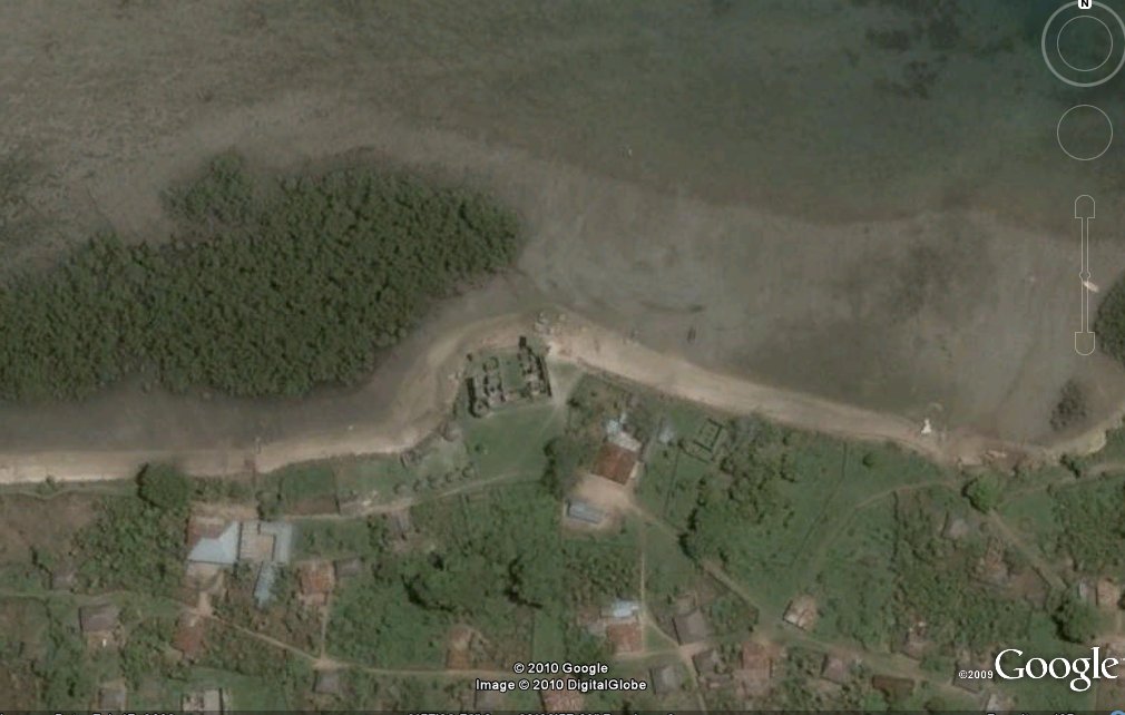
When On Google Earth 100

Moore Group is delighted to present When On Google Earth 100 after Declan solved Ferhan’s When on Google Earth 99(which was Erebuni Fortress in Yerevan, Armenia). Started by Shawn Graham back  in January 2009, the game owes it’s origins to a geological game (Where on Google Earth) which has been around for a little longer. Shawn has a near complete list of the previous winners here.

The Rules of When on Google Earth are simple:
Q: What is When on Google Earth?
A: It’s a game for archaeologists, or anybody else willing to have a go!

Q: How do you play it?
A: Simple, you try to identify the site in the picture.

Q: Who wins?
A: The first person to correctly identify the site, including its major period of occupation, wins the game.

Q: What does the winner get?
A: The winner gets bragging rights and the chance to host the next When on Google Earth on his/her own blog!

The Facebook group is here: http://www.facebook.com/group.php?gid=84104363322

So here’s When on Google Earth 100…