Blog

OKTOBERFEST

Given that Moore Group has now survived ten years, and we’ve been blogging 4 years, we thought we’d share a ‘best of the blog’. Over the next few weeks we’ll post some of the better (in our mind) posts from the past few years. Our first blog post was in August 2007 and the count is now over 300 with over 700 comments. There’s a huge amount of very varied content on the blog, so please explore. there’s everything from lizards to planning to beer. So here’s the first ‘best of’ – a report from our trip to Oktoberfest in 2007. All part of our detailed research into the archaeology and history of beer, and done for purely scientific reasons, of course……

Oktoberfest

Munich’s Oktoberfest began in 1810 as a horse race to mark the marriage of the Crown Prince (Ludwig – see footnote) of Bavaria, later King Ludwig I (1786 – 1868) to Princess Therese of Saxe-Hildburghausen. The race was soon combined with the state agricultural fair, and food and drink offered. In the late 20th century the Munich breweries began setting up large temporary beer halls. Today the festival lasts two weeks and ends on the first Sunday of October. The stat’s are staggering: total beer consumption during the festival topped 6.9 million litres in 2006 and 6.5 million revellers consumed 102 roasted steers, 144,635 pairs of sausages (still don’t know why sausages are paired!), 500,000 roast chickens and 43,492 knuckles of pork. The festival is still held at the 42 hectare Theresienwiese (Field of Therese – maybe it should have been named Lola’s field? – see footnote), often called “d’ Wiesn” for short.

D’Weisn

Our first job is to recce for the rest of the company, to find the Wies’n, the 42 Ha former race course. Our plan a simple one – just follow the men in lederhosen and skip around the Beirleichen (“beercorpses”), taking care to avoid the hordes of drunk Aussies, Brits, Micks and Americans.

Day One, our destination is the Löwenbräu-Festhalle – first though, the three of us wander aimlessly through the park, gazing in wonder at the strange mechanical stalls, the never-ending food outlets, roundabouts and rides and the vast beer tents, mouths open, flies undone (like the Connemara man in Loch Vegas staring up at the Highscrapers). We’re lost in a giant German wonderland, surrounded by sausages, clockwork clowns, ghost trains and shooting galleries. Our senses are overwhelmed. No-one speaks, no-one leads, we just know where we’re going – somewhere to the left, the right and straight on, towards the big ferris wheel, via a burger joint, left at the laughing clown and wherever the path takes us. By midday, the place is host to what must be 200,000 beer fans. Here are all the Müncheners, Bavarians and people from every corner of the planet of every age and ethnic background dressed in their dirndl and lederhosen, about to consume vast quantities of food and beer. This is heaven, but loud, a loud sort of heaven, a great, big, busy lederheaven (sorry). This is where all the research has been leading, four years of hard work, four years of over-indulgence, all leading to this, the Löwenbräu tent at Oktoberfest.

Löwenbräu-Festhalle

It’s vast, at least 8000 people must be in here, and within minutes we hear the first chorus of the song we will know so well by the end of the day – ‘Ein prosit, ein prosit, gemütlichkeit…ein prosit, ein proooooosit, gemutlichkeit!’. Above the entrance is a 4.5m high lion who occasionally drinks from his beer. He is overshadowed by another tower where another drinking lion sits. Dead centre, there’s a bandstand, a brass band plays Oompah music, people are cheering, people are drinking, it’s awe-inspiring. But we’ve heard that 12:30 is way too late to get a table so we don’t have time to take this in, instinct takes over, we’re focused, we must find a seat. We pounce – six Argentines (Argentinians?) spot the empty table, but they’re too late, too polite, too weak – we beat them to the table and quickly all three of us spread out, stake our territory and glare. If we could urinate at each corner, we would. We win – at least we’ll beat the Argentinians at something this week.

Seconds later we are joined by our neighbours, three sweet young German men – let’s euphemistically refer to them as ‘sports enthusiasts’ who are liable to ‘collective effervescence’ (SELCE’s) – they quickly become our greatest friends. We make polite enquiries about their tattoos, but think better of that after a short, stilted conversation, let’s just talk about beer and soccer! Better. Then our first Maß (litres of beer) arrive, and all becomes a whirlwind of beer, choruses of ‘Ein prosit’ and more beer. We’re joined by some Aussies, some Kiwi’s and some Italians. Three hours pass, our other travel companions from home arrive and quickly leave to find a table – we don’t see some of them again for three days.

As Jack Bauer once said – ‘ we’re in a level three hot zone’, but he was talking about the Marburg virus, hemorrhagic fever and a suitcase nuclear device and we’re talking 10,000 toasts, whole and half chickens, Maß, sauerkraut and those ‘pairs’ of sausages again, but the danger for us is just as serious. We are risking our health and well-being in the name of science. But it’s all so incredibly good-humoured. We see no sign of violence, no sign of the hordes of drunken Aussies, no anger – it’s all love, all joy, all good fun. This is so not Ireland, like, not, whatever.

About two hours later we are moved on, our table reserved for some other Beirleichen. Our German friends depart, we head to the Augustiner Brauerei where things quickly fade into a haze of faces, strange hats and a range of nationalities. The Aussies are first to fall, followed by one of our company, and later, much later we stagger home to our hotel, waking up some time the next day.

Day 2, Day 3, Day 4

Day Two – Take Day One, stir, add different ingredients and repeat. Day Three, Ditto, Day Four, Get plane, Go home, Rest.

Home

It’s an event we’ll definitely go to again – but we’ll need a few years rest. While we did hear of some aggression and some reports of violence, the whole event is so good-natured it’s bizarre. Coming from Ireland, where even the German ambassador is appalled by our vulgarity, it’s difficult to see how an event like this, if anyone ever considered it, could work at home. Surely it would descend into a drunken, disgusting brawl. Or maybe I’m being too harsh, maybe we’ve all grown up, maybe an event like this could work at home.

We will of course attend the first Great Irish Beer Festival in Galway on the 20th of October to see how it goes and report back honestly and bluntly. And we’ll post the full Archaeology Ireland Article in the next week, here as opposed to the website. In the meantime Prost!

* Footnote

Ludwig suffered many scandals, not least those associated with one of his mistresses, Lola Montez/Eliza Gilbert. Lola, an Irish-born dancer and actress, as well as an infamous courtesan, gained notoriety throughout the world for her exotic dancing (Australian historian Michael Cannon says “In September 1855 she performed her erotic Spider Dance at the Theatre Royal in Melbourne, raising her skirts so high that the audience could see she wore no underclothing at all. Next day the Argus thundered that her performance was ‘utterly subversive to all ideas of public morality”). She earned further notoriety in Ballarat when after reading a bad review in The Ballarat Times she chased the editor, Henry Seekamp with a whip. We were reminded of her in Ballarat during a visit to Sovereign Hill in February where we saw a poster pinned to a wall advertising her appearance that evening. Montez is fictionalised in Royal Flash by the late George MacDonald Fraser, where she has a brief affair with Harry Flashman.

Georg Dury (nach Joseph Stieler) Lola Montez 1848 – Münchner Stadtmuseum

IRELAND AND THE ‘VAGARIES OF WAR’

This piece was originally published at the Archaeology Group Blog: Then Dig last month…

There’s a somewhat long tirade by way of an introduction to this post on distance, perceptions from afar, and the current state of Ireland so, indulge, or bear with, me while I set the scene!

Writing in the Irish Times just before the visit of the queen of England to the Republic of Ireland in May, wherein, as we are not subjects of her majesty, we are not required to bow or curtsey, or capitalise the word ‘queen’ (I may have made that last bit up – or my Republican Grandmother did), Irish comedian Dara Ó’Briain notes that:

‘There is a joke that all Irish comics have a version of, but the most economic expression is from Andrew Maxwell. He would declare in an English comedy club “The Irish love the Muslims…” and after a long, long pause, “They’ve really taken the heat off us”.’

Ó’Briain’s point is that, in Britain, the Irish have ceased being identified a major ’terror threat’. We have been normalised in British society. The visit of the queen signals a further stabilisation of our relationship with our nearest neighbours and the culmination of a long and difficult peace process on our Island. Unfortunately no member of the public, other than some local celebrities (they’re always smaller than you thought, you  know) were allowed within 50km of her majesty, in case we’d do something embarrassing like keep our hands in our pockets or something! Our local media framed the visit as ‘the Nation growing up’, a sign of our ‘maturity’, and carefully sanitised the past.

(Photo: Whitehouse)

President Obama’s later visit, predicated on his (very) tenuous family links to a small village in County Offaly (see Moore Group’s blog here), took place over less than 24 hours, and copper fastened his vague Irish credentials, as well as providing US media outlets the golden opportunity to promulgate the great Irish clichés (drink) and document the new national stereotypes – our newly poor property developers and other Celtic Tiger grotesques (sorry, but I’m too stuffed with potatoes, and langered with porter to summon up any outrage). Inevitably, the local media for both visits were fawning and obsequious, and internationally the most memorable images presented were of a British queen politely ignoring a pint of Guinness, and an American President embracing one (and sinking it with gusto). Guinness, owned by the multinational company Diageo, had a great advertising opportunity and, after the guests had left, promptly announced 400 future layoffs. No mention or query during Obama’s visit about US treasury secretary Timothy Geithner’s apparent blocking of an IMF plan to allow Ireland to burn some of our bondholders, thus maintaining the financial burden on the country and adding greatly to our general misery and wretchedness – no, it was all hugging babies, our two countries being bound by affection, history and friendship…. Nice articulate, inspiring, bondage, nonetheless.

Meanwhile back in the US, Imagine Ireland is pitching Irish ‘Culture’, which according to their website ‘is the means by which most Americans now encounter Ireland’. Funded by the Irish Government, the project aims to connect with Irish-Americans (all 40 million of them – down mysteriously from 70m in the previous census [maybe I made that up too]) and other Americans (all 271,353,043 of them), by presenting a wide ranging programme of arts and cultural events and collaborations across the States.

‘Brand Ireland’ has clearly been in overdrive for the past month.

These events, and the associated marketing, are all part of a huge effort to repair our perceived international reputational damage as a result of our economic collapse, to change our tourism pitch from the overly expensive Celtic Tiger garish spa tourism of the early 21st century to ‘culture’ (archaeological sites, music and drink) and green tourism, and to present a new, positive face to the world. So, the main pitch of our tourism chiefs is that Ireland is a place of fun, stout and ‘the craic’, with green fields and archaeological sites featuring prominently in that marketing, depicting a country which is both rural and traditional. The Presidential and queenly visits provoked an all-pervasive ‘positive thinking’ rhetoric in both the new and old media and even infected the pubs (the cynics have only now in the past week begun to rear up again). In the end this might sell a few more pints of Guinness over the next few years and fill up our empty hotels (financed by ill-advised tax breaks for the ultra-rich in the noughties).

From the dizzying heights of the Celtic Tiger years, when we were ‘the envy of the world’, a shining light of economic openness, Ireland has now descended into economic freefall, and our cultural heritage sector has not escaped the collapse. The current best estimate by the Institute of Archaeologists of Ireland (IAI) of numbers working in the profession is 350 – from a peak of 1700 in 2008. This may even be overestimated, as, anecdotally, we’re hearing of widespread unemployment nationwide, with people working only sporadically and others on short term or part time hours, a scenario reflected in my own business, which now employs 4, down from a peak of 18 four/five years ago.

It’s in this context that my attention was drawn to the recent AIA ball and its focus on Ireland. Part –funded by Imagine Ireland as an element of their great American Journey, the Gala was addressed by our cultural ambassador, Gabriel Byrne (of In Treatment and Bracken fame). The event seems to have been a great success and showcased our remarkable cultural heritage and stock of monuments with apparently excellent addresses by both Pat Wallace of the National Museum of Ireland and Gabriel Byrne; but I was surprised by a small paragraph describing how some of the proceeds from the Gala were to be used:

Each year hundreds of irreplaceable archaeological sites are destroyed by unrestrained development, looting, the vagaries of war, and environmental changes.  With the help of gala attendees, we are able to preserve these sites for the future.

During the Gala, guests had the special opportunity to  support the AIA’s efforts to preserve Irish cultural heritage—a portion of the proceeds from the Gala auction will be used to directly support archaeological sites in Ireland…

This may be a case of a simple cut and paste on the part of an AIA website editor. However, it did elicit a brief stir on twitter with a few Irish archaeological tweeters noting the tone and import of the paragraph, a paragraph which was later repeated in the introduction to a new AIA Irish Archaeological Heritage Google Earth skin announced here. As Charles Mount points out in his blog ‘I hope this misplaced rhetoric won’t discourage any visitors to Ireland’. Further to Charles’ blog post the section was removed from the Google Earth announcement on the AIA site (although it still appears on the ‘Saving Irish Sites‘ section of the website).

With regards to ‘the vagaries of war’ mentioned therein, it should be pointed out that the conflict in Ireland is a sensitive subject and we have gone through a long and difficult peace process, building on the 1998 Good Friday agreement. Ireland is now one of the safest places in the world (consistently ranking in or around the world’s top ten safest and most peaceful places).

We haven’t had war in the Republic for 90 years (both my Grandfathers were locked up for that one – but that’s another story), we have one of the lowest murder rates in the world, no one carries a gun, and, shure, we’re half stupefied with de demon drink most of the time, so, ‘vagaries of war’ – not a threat to our cultural heritage or prospective visitors…

As to unrestrained development: Well, the recklessness of our bankers and the hubris of our property developers, aided by ineffectual government, political clientelism, the general global collapse and our innate cute-hoorism (see here and here) has put the kibosh (which word some would say is derived from the Irish word Cabáiste meaning ‘cabbage’, or caidhp (an) bháis meaning ‘cap of death’) on that.

Looting in Ireland has not been a huge problem, metal detectorists require a licence to prospect in the vicinity of archaeological sites, and our legislation, described by someone as ‘the most draconian’ in the world  ensures strong protection for our archaeological sites. In saying that, there was one disturbing recent incident of looting of a WW1 Uboat in Cork.

And, ‘environmental changes’; well apart from coastal erosion, sea level rise and other climatic processes, not a great problem…

No, the most pressing threat to Irish archaeology is none of the above… it is a combination of decreased funding, cut throat competition in an era of much reduced developer funded work, growing unemployment, emigration and the resultant brain drain. Experienced archaeological field workers face the choice of retraining, pursuing a new career path or leaving the country. Those who remain (and are lucky enough to have a job) face a different challenge – crap conditions and pay….   a reversion to the bad old days when archaeology was seen as a ‘vocation’ (this word is creeping back into the Irish archaeological lexicon and should be taken as code for badly paid, crap conditions), a job you do for the ‘love of it’. From the anecdotal evidence this is becoming a reality, with indications that those who remain in employment at the lower grades are being paid barely above the minimum wage (which itself has been reduced, but will apparently be raised again shortly).

Another problem is dissemination of all the data from the past few years. The last 20 years have resulted in an unprecedented number of discoveries and a wealth of new information on Irish archaeology, the road and house building boom producing unequalled amounts of data, but this is so far largely hidden in technical reports and unpublished material archived in formal Department locations. Although state agencies such as the NRA (National Roads Authority, nothing to do with guns) are busy publishing the results of the road projects, and some of the surviving consultancies are getting their data out (witness eachtra’s exemplary Journal and our own humble blog), there’s still a danger that much of this information will get lost along the way, if the excavators leave Ireland or consultancies shut down or simply no longer have the resources.

I’ve a much longer list of the problems and dangers for Irish archaeology in my head, but I won’t go into them here. Anyone who wants to read more on the great challenges and apparent opportunities, just click here for a discussion document on the Archaeological Profession in Ireland, arising from a recent seminar facilitated by the Irish Heritage Council.

Doubtless there are dangers to our cultural heritage, but certainly not from the vagaries of war, nor from looting or unrestrained development (perhaps from environmental changes).

Irish commercial archaeology has come a long way, and our knowledge of our past is being transformed but right now we’re busy taking stock of where we are and where we’re going, in terms of our society at large and also in terms of our cultural heritage. Tourism and our well preserved and presentable cultural heritage is an integral part of our future sustainable survival and perceptions from distant markets are important to that future. Our nations story of progress to independence, through poverty and emigration, sudden wealth and subsequent collapse, with the prospect of lasting unity and peace has not been untroubled, but, despite my earlier cynical tone, that trouble is largely behind us, and we wholeheartedly welcome all our visitors…  and they can rest assured that we won’t hurt them.

And as a reward for getting all the way to the end, please stand for Ireland’s alternative national anthem…

PEARSE STREET ATHLONE MONITORING

Pearse Street, Athlone, Co. Westmeath

Archaeological Monitoring

20365 24120

NA

10E430

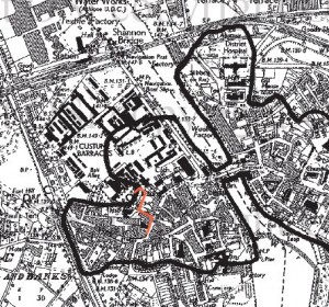
A programme of archaeological monitoring was carried out in the vicinity of the Revenue Commissioners Building off Pearse Street, Athlone, Co. Westmeath and along Pearse Street.

The works involved the installation of a proposed gas main extension along Pearse Street (approx. 77m of 125mm diameter pipe) and a site main/service pipe on the revenue commissioners’ property (approx 200m of 90mm diameter pipe). The pipe was laid by open cut trenching with maximum trench depth of 1m.

The groundworks took place along Pearse Street on the western bank of the Shannon.  From historical records we know that development on this side of the river dates from before 1200. There is a tradition that the priory of saints Peter and Paul was founded by Toirrdelbach Ua Conchobair in or about 1150, as part of a 12th century ecclesiastical reform movement. This foundation, based as it was near a fording point, had obvious strategic importance that was subsequently recognized by the Anglo-Normans. bishop John De Gray of Norwich built the first castle for king John of England in 1210 and the existing building still incorporates elements of this original design. The castle was built to protect a bridge leading to the East Town on the opposite bank; the castle was surrounded with strong walls and a ten sided donjon. After Cathal’s death in 1224 the town was burnt by his son Aedh during the ‘troubles in Connacht’, after which the province was granted to Richard de Burgh. The town was clearly a significant enough place in the 13th century for the Franciscans (Greyfriars) to establish a house there. A murage grant dates to 1251, when the justiciar John Fitz Geoffrey was provided with 80 marks to enclose Athlone and Rindown (a nearby town on the west of the Lough Ree), and to repair the castles. Down through the years the castle has had various additions and alterations made in response to advances in warfare.  It has many of the characteristics of a Napoleonic fortification as it was remodelled during that period to defend the crossing point of the Shannon. From about 1697 a military barracks existed in Athlone on the site still occupied by Custume Barracks today. The streetscape that developed around the Castle and Church was constrained by local topography, the main western approach road and the development of 17th century defences and 18th century batteries. The present day plan is based on a post medieval template that grew organically but was reordered and widened in the early 18th century.

The groundworks were carried out within the zone of archaeological potential for the historic town of Athlone.

RMP Map showing pipeline route

Monitoring of groundworks for the gas pipe installation took place in November 2010. To minimise traffic disruption the majority of the works were carried out at night under flourescent light. The trench depth was generally between 800mm and 900mm. The stratigraphic profile recorded consisted of tarmac and hardcore infill 0–200mm in depth, below this was a yellow clay mixed with numerous red brick fragments and small stones. This profile was generally uniform throughout but was interrupted frequently by a complex of modern services including water and sewerage mains as well as a number of smaller domestic connections. No finds, features or materials of archaeological significance were recorded.

Declan Moore, Moore Archaeological & Environmental Services Ltd. (MOORE GROUP), Corporate House, Ballybrit Business Park, Ballybrit, Galway.


10 YEARS OLD (Our first advert)

We’ve just realised that Moore Group is now 10 years in business. So, to mark ten years, we’ll have a series of events over the coming months (small ones – can’t afford much in the way of big events, so no fireworks or suchlike). We’ll also indulge in a little retrospective here on the blog.

Moore Group is a little different in terms of the way we do business and the type of business we do. We’re the only service provider in the country who provide both archaeological and ecological services, and we’re proud to say that, so far, this diversity of service has served us and our clients well. We’ve a great core team of professionals and the  four of us have been together for virtually the whole ten years. We started small, grew a little, and at one point had almost 50 people on the books, with a maximum full-time staff of 18, but, given the times we’re in, we’ve shrunk again to the core four, with Moore Marine as our adjunct.

So forgive us while we get a little self-indulgent on the blog over the coming months.

The company began with just me (Declan) in 2001. I was fortunate to win a small excavation contract in Manorhamilton, Co. Leitrim for the North Western Health Board, which helped kick off the company and allowed me to hire the excellent Tom Rogers, who has now moved back to the UK. Tom contributed  a great deal to the company and helped develop the product we have now.

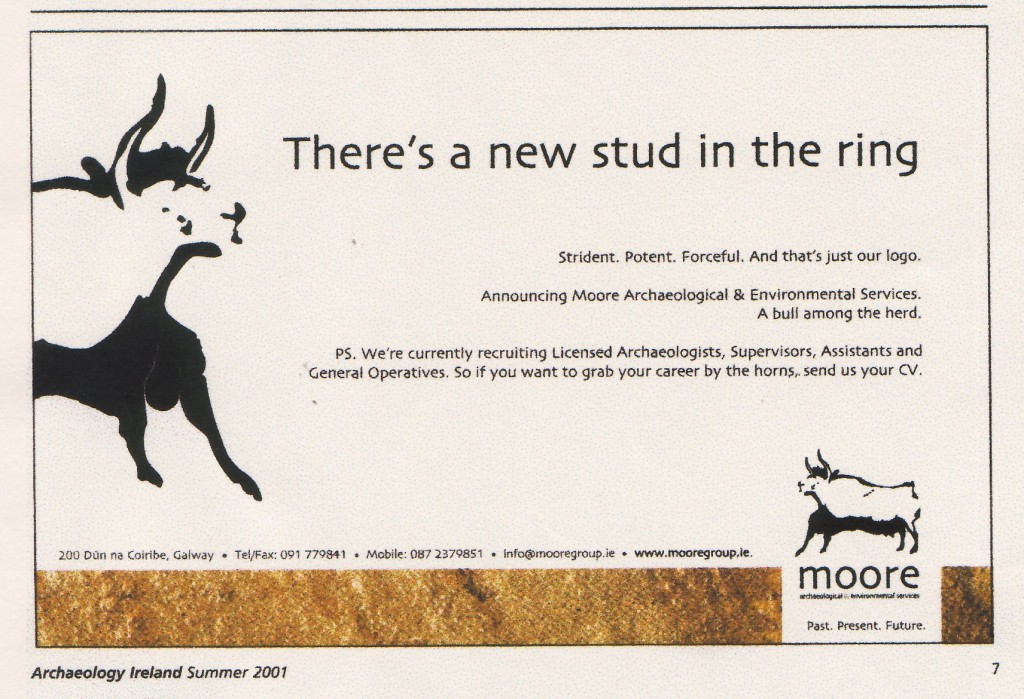
We announced ourselves (a little stridently) in the Summer 2001 Issue of ‘Archaeology Ireland’ with this advert designed by Bloom Advertising in Dublin (a very creative bunch indeed), which we’re reliably informed raised a few eyebrows… No idea why!


SLIGO TOWN MONITORING

Various, Sligo Town

Archaeological Monitoring

Various

Various

10E285

Archaeological monitoring of engineering slit trenches and test pits in advance of the proposed Sligo town Water Conservation scheme took place around Sligo town and environs between mid October and mid November 2010. Moore Group, in a previous archaeological assessment (March 2010) for the project, had demarcated a defined area of archaeological potential around the medieval centre of the borough. Within this area all groundwork’s associated with the site inves

tigations were monitored and recorded. The slit trenches ranged from 5m to 15m but were typically 10m in length by 0.55-

0.8m in width. All the trenches were mechanically excavated to an average depth of 1.3m. Depths did vary depending on the location of services and occasionally exceeded 2.5m. Using existing service maps as a guide the contractors attempted to determine the location, depth and extent of the in situ pipe work. The service infrastructure encountered ranged from 19th century stone and bri

ck culverts, lead pipes, cast iron mains and more modern services. Due to the multiplicity of services the stratigraphic profile generally consisted of upper deposits (300-500mm) of modern fills including gravels and coarse sand overlying redeposited sand and occasionally builders fill (up to 700mm in depth). Natural clayey sand with a medium amount of stones varied in depth given the level of disturbance but ranged from 400mm to 1m. Near the banks of the Garvogue River and along what would have been the old flood plain much of the subsurface deposits were made up of a composite of re-deposited alluvial silts and sand. The underlying parent material throughout the subject area consisted of compact calcareous gravelly loam till of predominantly Carboniferous limestone composition. Weathered bedrock was occasionally encountered particularly on the northern bank of the river but not in concentrations that impeded the works.

During the course of the monitoring brief very few in situ deposits of archaeological potential were identified. This was partially due to the fact that when services were exposed, digging ceased and it was not possible to investigate the material below. Furthermore much of the underlying deposits along the streets of Sligo have been disturbed or removed by modern excavations.

The following section presents the summary results of the monitoring programme:

Johns Street.

Six 10m long slit trenches and eleven test pits were excavated along the length of Johns Street in the vicinity of the graveyard of the Church of Ireland Cathedral. Excavations along the roadway exposed modern fills below the road base overlying a natural grey brown, clayey sand with occasional medium sized stones. Within the fill material for the older services including the stone culvert (circa 1850’s) and the original cast iron water main were a number of disarticulated animal bone fragments, these remains were noted but were not considered significant. Other stray finds included occasional modern pottery sherds and metal debris. There was no evidence of earlier structural remains or finds or materials of archaeological potential.

Smiths Row and City Centre Car Park.

Five 5m slit trenches were excavated along the length of Smiths Row and the adjoining car park. Excavations exposed modern rubble fill below the road base overlying a natural grey brown clayey sand. Within ST5-088O along the west of the car park there was evidence for a dark organic horizon at a depth of 400mm that contained fragments of red brick. No other stray finds were recovered or materials or features of archaeological potential were evidenced.

Pearse Road.

Five 10m slit trenches and two test pits were excavated along the length of Pearse Road between the junction of Old Market Street and Burton Street. Excavations exposed a number of modern services cut into a grey brown compact natural sand. There were no finds, features or materials of archaeological potential noted in this area.

Old Market Street.

Four 10m slit trenches were excavated along the length of Old Market Street between the Pearse Road and Burton Street. Excavations exposed a number of modern services cut into a rubble layer with old builders fill and grey brown compact natural sand particularly in ST10-117. It is worth noting that there are a number of in situ cobbled areas along the western side of this street that have the potential to protect earlier historic layers. There were no other finds, features or materials of archaeological potential noted in this area.

Connolly Street.

Seven 10m slit trenches and five test pits were excavated along the length of Connolly Street and the Junction of the Mail Coach Road. Excavations exposed a number of modern services cut into a compact grey brown natural sand. The only notable feature was found in ST5-127 to the south of the street. Beneath the road base at a depth of 500mm was a brown organic rich deposit containing a concentration of both oyster and periwinkle shells. This in situ historic layer has moderate potential to contain finds of archaeological significance.

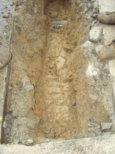
Cobbles on The Mall

The Mall.

Thirteen 10m slit trenches and six test pits were excavated along the length of the Mall. Excavations exposed the usual frequency of modern services cut into road base, modern fills and grey brown compact natural sand.  The one exception was a layer of cobbles exposed under the footpath at ST10-035. These cobbles represent an old surface that possibly pre-date the existing Georgian terrace (originally Gore Street). The cobbles were well sorted and made up of water rolled, sub rounded stones in a compact layer. The depth of the cobbles relative to the adjacent properties suggest a mid 18th century date.

Further west along the mall, in the vicinity of the carpark, the stratigraphy had a deposit of builders fill under the road base consisting of dumped stone, plaster, mortar and red brick. There were no additional finds, features or materials of archaeological potential noted in this area.

Holborn Street.

Three 10m slit trenches were excavated along the southern half of Holborn Street. Excavations exposed a prevalence of modern services cut into a deposit of brown clayey sand overlying grey brown natural sand. A number of disarticulated animal bones and shell were noted in ST05-073. There were no other finds, features or materials of archaeological potential noted in the area.

Stephens Street and Stephens Street Car Park.

Eight slit trenches were excavated along Stephens Street and the adjoining car park. Along the road the stratigraphy was mostly made up of modern infills overlying natural clay, within the car park, however, in slit trenches ST5-076 and ST5-078 a layer of dark organic material was observed at a depth of 300mm. This layer had fragments of red brick. There were no other finds, features or materials of archaeological potential noted in the area.

Teeling Street.

Four slit trenches and two test pits were excavated along Teeling Street. The stratigraphic profile was made up of underlying modern in-fills over natural clay. There were

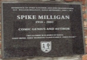
Holborn Street, Home of Grandfather and Father of Spike Milligan, Comic Genius and Author

no finds, features or materials of archaeological potential noted elsewhere in the area.

Thomas Street.

Three slit trenches and two test pits were excavated along Thomas Street. The stratigraphic profile was as previously described. ST10-84 along the bridge was dug to a depth of approximately 2m and was made up of re-deposited sandy with occasional medium sized stones. The remaining slit trenches exposed a red brick culvert probable dating to the 1850’s. A small concentration of oyster shell was noted in the fill over the old water main.

Bridge Street.

Three slit trenches were excavated along Bridge Street. Within ST10-079 to the north of the road a cobbled layer was exposed at a depth of 650mm. These cobbles were located 3m from the western terminal and extended under the footpath. To the east they were truncated by a modern service. Elsewhere the stratigraphic profile consisted of reddish brown silty sand overlying natural dark brown clayey sand.

Castle Street.

Three slit trenches were excavated along Castle Street. Groundwork’s exposed the usual frequency of services including the old stone lined culvert. Within ST10-092 a silty deposit was found at a depth of 550mm containing concentrations of sea shells. This layer was partially truncated by a broadband installation. Elsewhere the stratigraphic profile consisted of road base overlying re-deposited rubble fill and natural sand. There were no other finds, features or materials of archaeological potential noted in the area.

Grattan Street.

Two slit trenches were excavated along Grattan Street exposing a large red brick vaulted culvert lying beside more modern services. Due to the extent of previous disturbance there was not much natural ground visible. There were no finds, features or materials of archaeological potential noted in this area.

O’Connell Street.

There were no slit trenches excavated in O’Connell Street, however there were a number of test pits excavated. All of these were sited to investigate specific services and therefore were of no archaeological interest.

Wine Street.

Seven slit trenches were excavated along Wine Street exposing mostly re-deposited service fills overlying grey brown natural sand. Occasionally beneath the road base was a dump of builders fill containing rubble stone and red brick fragments. There were no finds, features or materials of archaeological potential noted in this area.

Quay Street.

Four slit trenches were excavated along Wine Street at night exposing mostly infilled ground with builders rubble and fragments of red brick over a stone lined culvert and more modern services. There were no finds, features or materials of archaeological potential noted in this area.

Lower Knox Street.

Two slit trenches were excavated along Lower Knox Street exposing disturbed sandy ground cut with modern services and fills. There were no finds, features or materials of archaeological potential noted in this area.

Lower Quay Street.

Five slit trenches were excavated along Lower Quay Street exposing a number of services including broadband ducts and a cast iron water main cut into re-deposited compact grey brown sand. Along the middle of the street, near a possible late 18th century property, excavations in ST10-65 uncovered a small rubble stone and mortar wall foundation that ran across the width of the trench and measured 300mm wide by 350mm in height. The wall was roughly orientated north south and was located 300mm from the footpath on the eastern side of the trench. The wall was constructed of cobble sized sub rounded and sub angular stones and was bonded with a dense sandy mortar with shell inclusions. Three courses of stone were exposed. Several deposits including an ash deposit and brick inclusions were visible in the south facing section on the western side of the wall. Deposits on the eastern side of the wall had been disturbed and backfilled with hardcore, There were no finds, features or materials of archaeological potential noted in the remaining trenches.

Union Street.

Five slit trenches were excavated along Union Street exposing mostly modern infills  with little evidence for in situ deposits. There were no finds, features or materials of archaeological potential noted in this area.


Despite years of successive redevelopments and Street widening it is still possible to encounter in situ material with significant archaeological potential. During the monitoring programme cobbles were found both along The Mall and Bridge Street. In Quay Street an unrecorded wall foundation was exposed, this foundation could be associated with structural remains from the old harbour. Within the town centre 19th century stone and brick lined culverts and more recent service works have removed much of the earlier deposits along the roadways. Notwithstanding this in outlying streets notably Connolly Street and to a lesser extent Holborn Sreet and Thomas Street there were occasional pockets of organic rich material that contained disarticulated animal bone and shell. These dump deposits generally contain finds and are of archaeological interest. Also evident from within the slit trenches were dumps of builder’s rubble. This material has the potential to contain medieval fabric or architectural fragments.

Declan Moore, Moore Archaeological & Environmental Services Ltd. (MOORE GROUP), Corporate House, Ballybrit Business Park, Ballybrit, Galway.