BRONZE AGE SETTLEMENT IN ORANMORE

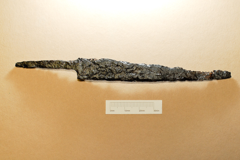
This post is more from a series of posts on the exciting results of excavations carried out by Moore Group at Pairc and Clochair, Oranmore, County Galway between 2008 and 2010. A number of sites were excavated in advance of construction of a new supermarket and associated access and other services. This time – a Bronze Age Settlement site. this site was excavated by Tamyln O’Driscoll and the following is from her report. In this post we’ll provide a little background and describe the finds. Next time a detailed description of the Bronze Age Structure and then some info on the environmental remains from the site (I know that that’s an Iron knife pictures above but read on – there was also some later material).
Bronze Age settlement sites – a background.
Bronze Age houses in Ireland were generally sub-circular structures or roundhouses with diameters of between 2m and 9m, generally with south-east facing entrances and some examples even had porch entrance features (for details of a bronze age roundhouse excavated by Moore Group in County Clare see here). In some upland areas stone was used for the construction of these houses however the majority were built of wood either post built or foundation trenches, in some circumstances both methods of construction was employed. Excavations of a Late Bronze Age hillfort at Mooghuan South Co. Clare revealed extensive layers of occupation debris which included two small circular house structures. During the excavation of the N8/N73 Mitchelstown relief road the foundations of three Middle Bronze Age houses were discovered. The houses consisted of shallow slot trench foundations, which was roughly sub-circular in shape and a hearth feature was also present, some had a central ring of postholes which would have held posts that were used to support the thatched roof structure. Like many of the other Bronze Age house sites, Feature 1 at Oranmore, the possible house site, also had a hearth feature further supporting a domestic use for the site. At Carrigillihy Co. Cork traces of two phases of house construction were excavated. The house sites were surrounded by an enclosing stone wall which was oval shaped in plan. The two houses overlay one another, the earlier house consisted of the stone foundations of an oval shaped structure that was superimposed by a secondary stone square shaped house. The earlier house dated to the Early Bronze Age to Late Bronze Age transitional period. In the floor of this earlier structure several pits of various sizes and depths were discovered (O’Kelly 1989 219-222). These bear similarities to the large pits discovered below the metalled floor surface of the possible house site at Pairc an Clochar (Feature 1). One of these large pits (Feature 2) which was found below the hearth and associated midden and contained a chert flake within the basal fill of the pit. It is likely from the finds and the comparative material from other excavated house sites that Feature 1 along with its associated hearth, midden and pits were indeed part of a Bronze Age house structure.
However unlike other Bronze Age houses the structure at Pairc an Clochar did not have any structural features in the form of postholes for roof support, gullies or slot trenches foundations nor was there an entrance feature. It is possible from the evidence that the site was located in a natural hollow and may have been a sunken structure, this design would have been necessary in the coastal location of Galway Bay where the weather conditions would have made a standard post built house impractical.
Location
Coastal occupation sites have been favoured from prehistoric times for their proximity to rich food sources and are often represented by habitation sites and middens. Shell middens are the rubbish dumps of the unwanted shells from oysters, limpets, periwinkles. Shellfish meat has been use as food source since earliest times up until the present. Shell middens of various dates are known around much of the Irish coast, two middens of prehistoric date were excavated at Sutton and Dalkey Co. Dublin (Waddell 1998, 19). Rivers were also important areas of activity, serving as route ways, boundaries, defences and ritual sites. The site was located on a gentle gradient sloping down to the seashore; this meant the site was well drained. It was also situated in this position to provide good views in all directions. The location of the site in close proximity to a Bronze Age ring ditch (which we’ll describe in a later post) also may have influenced the location of the Bronze Age settlement activity. It is likely that the occupants of the settlement site were also those that constructed the ring ditch and may have had ancestral ties to the location.
The Finds
The pottery recovered from Area 3 ranges in date from the Bronze Age (c2500 to c700BC) to the Late Medieval period (1300 to 1500AD) with occasional pieces of pottery also dating to the modern period. The pottery assemblage from the Bronze Age comprises thin wall fragments suggesting that the vessels were small-sized with extant wall thicknesses of 4-9mm. One sherd is from the basal area of a pot that may have had a slight foot. The assemblage is likely to have a domestic use as indicated by soot accretions on the inside of one vessel. One fragment appears to be from a mould fragment and was found in the primary fill of the sub-rectangular house Feature 1. The mould fragment does not have extant metal residues but the curvature is similar to mould fragments from Bronze Age metal-production sites such as Lough Gur, Co. Limerick and Dun Aonghusa, Aran Islands (Cleary 1995). During the Bronze Age clay moulds were used for casting a variety of bronze artefacts such as axes, knives and daggers. The presence of a mould at the site may suggest that smelting technology may have been conducted by the occupants of the site. Clay mould fragments dating to the Late Bronze Age have been discovered during excavations at Rathgall hillfort Co. Wicklow (Kelly 1989, 159). Further metal working activity is possible from the baked clay and slag items found at the site. However the material is not extensive enough to suggest that this activity occurred at the site and may have taken place nearby.
Several unidentified worked bone objects were found during the excavation of Area 3 and were all from the fill of a large pit feature, which also contained other unworked animal bone and the skeletal remains of a dog. Further worked bone objects were found which consisted of a worked pig metacarpal fragment with a circular perforation and a worked metatarsal from a sheep or a goat which may have been intended for use as a bone handle. These bone objects represent a continuity of industry at the site in terms of manufacturing of bone into objects from as early as the Bronze Age to the Late Medieval period.
An iron knife was found during the excavation of a large pit in the basal fill. This knife consisted of a thin metal blade which was likely to have been used as a domestic knife which would have had a wooden or bone handle attached. At Baronstown Co. Meath excavations revealed a circular ringfort dating to the Early Medieval period, amongst the finds uncovered at the site were several iron knives. At Cabinteely Co. Dublin a large pre-Norman enclosed cemetery was excavated, the sequence of burial took place from the 5th/6th century to the 11th/12th century AD. Amongst the finds discovered directly in association with these burials were a number of iron knives. Excavations at The Old Orchard Inn in Rathfarnham Co. Dublin revealed the site of a possible ecclesiastical site enclosed by a palisade enclosure. This early medieval phase of occupation was followed by the use of the site for burial purposes. The site was subsequently used again for occupation in perhaps the 12th or 13th century AD.
Iron knives were found in the palisade trench as well as a large amount of animal bone, a penannular brooch terminal, and a ‘pig fibula’ pin suggesting occupation of a domestic nature for the earlier phase of occupation. An iron knife, identical to the one found at Pairc an Clochar, was discovered during excavations at an Early Medieval enclosed settlement at Faughart Lower Co. Louth in advance of A1/N1 Newry to Dundalk road. The site consisted of a double ditched enclosure which expanded into an ecclesiastical cashel or stone fort, later the site was used for burial during the 5th to 6th centuries AD.
This entry was posted on Tuesday, May 7th, 2013 at 3:51 pm. It is filed under About Archaeology, Excavations, Finds, News, Papers & Reports, Virtual Museum and tagged with archaeology of Oranmore, Bronze Age Oranmore, history of Oranmore, Oranmore.
You can follow any responses to this entry through the RSS 2.0 feed.


br7tt2
j43rp1
x912t9
oof6r8
3izg4b
1psd6c