Bronze Age Roundhouse in Clare – Pt 1
During the course of archaeological monitoring of groundworks for a proposed reservoir site at Barnhill Wood, Dromoland, Co. Clare, a number of archaeologically significant features were uncovered. These features consisted of in situ articulated human remains, fire shattered stone, charcoal enriched material, associated pits and occasional burnt bone. This a part one of a three part post part 2 is here and part three – the references – is here and is quite long – continued under the fold after the first pic (if someone can tell me how to make a fold {figured it out!})…
This construction contract involved the provision of improvement works to the local water network in Newmarket-on-Fergus and was financed by Clare County Council. In addition to this new reservoir construction, the contract involves bringing treated water to Newmarket-on-Fergus from Castlelake Water Treatment Plant, near Sixmilebridge in conjunction with upgrading works at the Water Treatment Plant.
In consultation with the Department of the Environment, Heritage and Local Government, it was recommended that the subject area be hand trowelled, removing loose spoil and overburden and subsequently manually excavate two trenches to determine the nature and extent of the archaeology. Following this testing regime reports were lodged with the National Monuments Section of the DEHLG and The National Museum. Further consultations with the relevant authorities recommended that the proposed development area be fully excavated.

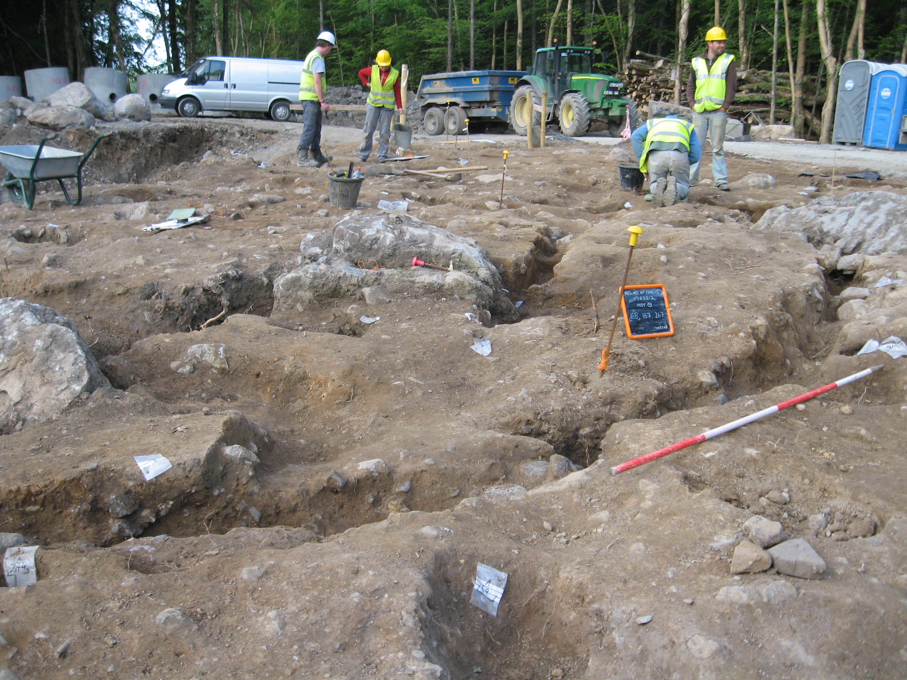
Work in progress
The site is located near the summit of Barnhill wood and is enclosed by a temporary haul road to the west and the proposed reservoir to the east. The existing subject area measures approximately 32m N/S by 14m E/W and despite being cordoned off was unfortunately over cut to the east resulting in exposed archaeological material being directly impacted on by machine excavation.
Evidence of Neolithic activities (4000-2500 BC) in County Clare is shown by the presence of several monuments such as the court tombs and portal tombs recorded in the Burren and artefacts typical of this period. A total of 124 wedge tombs have also been recorded in County Clare (Grogan and Condit, 2000). Recent research on prehistoric landscapes in Clare revealed the presence of significant Neolithic populations in the Burren and East Clare regions indicating a well-organised settlement landscape (Gill, 2006).
During the Bronze Age (2500-500BC) settlement continued and intensified (Grogan and Condit, 2000). Known sites such as the trivallate hillfort 1km east of the Dromoland Estate at Mooghaun appeared to have been constructed between 1159 and 917BC. The Mooghaun Hoard, comprising of 146 gold objects, collars, neck rings and bracelets, was found in a nearby lake. A number of rescue excavations in advance of the N18 road construction nearby yielded a high density of prehistoric archaeological features.
With its proximity to Mooghaun Hillfort and the strengthening evidence of prehistoric activity Dromoland Estate lies in an undoubtedly rich prehistoric archaeological landscape. Fulachta fiadh are considered to be the most widespread Bronze Age domestic sites. These sites usually consist of a U-shaped mound of burnt stone often associated with a water-filled trough (with a wide range of suggested functions). A concentration of fulacht fia were discovered during pre construction archaeological monitoring in the townland of Ballyconneely.
Ringforts, hilltop enclosures and other large enclosures are common across the undulating low-lying country around Ennis, both as raths (defended settlements defined by an earthen bank) and cashels (defined by a bank of stone). The smaller ringfort settlements are the most common monuments in south Clare and are thought to be small farmsteads, enclosing houses, farm buildings and animal pens, enclosed as protection against raiders or wild animals. Excavations of the interiors suggest that the houses were small circular huts, built of stakes with a double skin of wattle and a thatched roof (Stout 1997). Their distribution in the region is dispersed and widespread. A large number of ringforts are evident in the surrounding townlands of the Dromoland Estate with a number of enclosures sited within its limits, (CL042-055, CL042-056 & CL042-06202). With the seat of the O Brien clan located at Dromland Castle and a concentration of enclosures in the vicinity it is clear that this was a densely populated area within this settlement landscape during the medieval period.
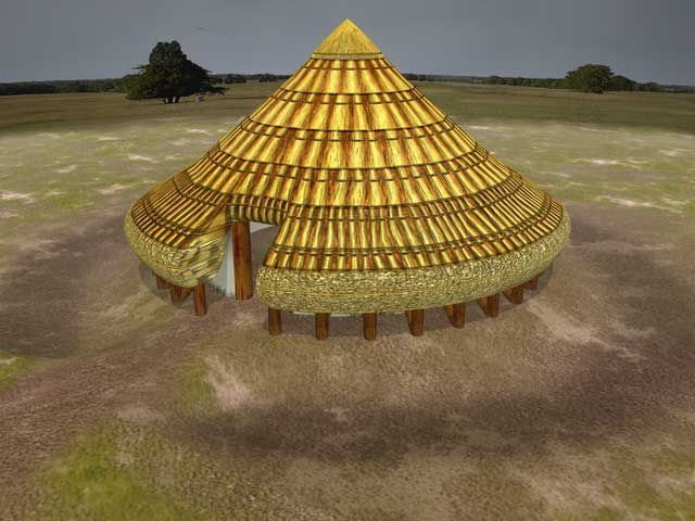
In 2007 Billy carried out an archaeological excavation at the Barnhill reservoir site in Co. Clare. The work exposed a multi phased complex consisting of a single roundhouse site defined by a semi-circular footing trench approximately 11m in diameter with external postholes, possibly sockets for slanting rafters. Internally there was a slot trench running north-south marking an internal division with ancillary pits and postholes. Outside the structure there was an assortment of small pits and post and stakeholes. To the N of the roundhouse was an 8m ditch, 1.95m wide and 1m deep. This ditch in all probability forms a section of an enclosing element or defensive fosse.

3D reconstruction of a Bronze Age round house from the Warwick Blog
The Barnhill house conforms broadly with Martin Doody’s classification of Bronze Age houses in Ireland having a round timber ground plan with a single footing trench and a single outer ring of postholes (Doody 2000). In terms of diameter the majority of round house sites (over 60%) are between 5-9m in diameter, which makes the Barnhill house exceptional in terms of its size. Unfortunately as only half the house survived it is impossible to comment on internal supports, the location of the hearth or the entranceway all of which were impacted on negatively during the course of initial construction clearing works. The roundhouse and enclosing ditch at Barnhill should be assessed in terms of interactions with the wider archaeological, social and natural environment of the Fergus Estuary and specifically the regions natural focus, Mooghaun Hillfort. According to Discovery Programme researchers the sphere of influence of Mooghaun increased during the Late Bronze Age and it became a regional center surrounded by associated sites up to about 176km sq. (Grogan et al. 1996). Furthermore it is understood that the organization of hill forts suggest a settlement pattern that represents a regional scale of settlement organization.
The Discovery researchers believe that a four-tiered system of hierarchy existed in the area around Mooghaun at this time. The four tiers are described as “substantial sub-regional centers represented by larger hillforts, lesser local foci in the form of smaller hillforts,” followed by “smaller hilltop enclosures [and] enclosed habitations” (Grogan et al. 1996). The hill forts may then have served as ritual centers linking these outlying areas in some way. Their massive construction and seemingly small number of inhabitants implies that people from the surrounding area must have had an incentive to help in the construction of these forts. Barnhill, given its proximity to Mooghaun hillfort, would slot into this regional network and its true significance has to be appreciated in this context. However it can be surmised that given the sites hilltop location, and its excellent views in all directions the Barnhill house probably functioned as a defensive outpost for the larger Mooghaun complex.
The latest event on site was the development of cultivation ridges or ‘lazy beds’. These ridges are likely to be post medieval in origin and their unlikely setting on top of a hill is indicative of the pressures on available agricultural land in the late eighteenth and early nineteenth century.
In parts 2 & 3 we’ll go into more detail on the excavation and the human remains and present a bibliography for further reading.

Link to Warwick Round House Excavation: http://blogs.warwick.ac.uk/warwick4000/gallery/site_5
This entry was posted on Wednesday, February 4th, 2009 at 12:53 pm. It is filed under About Archaeology, Papers & Reports and tagged with Archaeological Consultant Galway, Barnhill, bronze age, Clare, Dromoland, Mooghaun, Roundhouse.
You can follow any responses to this entry through the RSS 2.0 feed.


Have you posted a plan of this building?
Hi Geoff. I’ll ask Billy to do a short descriptive post on the structure and post up the finished plan over the next few days – before he goes off to excavate a fulacht fiadh up-country…
Dec
Thanks Dec That’s great – fulacht fiadh is that Irish for barbeque?
Rough version of plan posted this evening – we’ll post a better quality version next week..
Fulacht – Irish for ‘Pico-Brewery’!
Thanks Dec – lots of postholes and a slot what more could you ask for
Fulacht – Glad to see the traditions of the profession being upheld.