Tramore Wreck
The second of the Moore Marine Posts, posted by Eoghan:
Historic Map indicates cause for Tramore Shipwreck
During the course of archaeological monitoring of the Tramore Sewerage scheme, the remains of a previously unrecorded timber vessel was uncovered and investigated by a team from Moore Marine. These remains were located c.1km east of Tramore promenade, in an area of flat sandy beach close to the Low Water Mark. Upon exposure the wreck remains were seen to be those of a carvel laid double planked vessel. All planking was held in place by treenails with the plank ends butt jointed to its neighbour. The form and size of the vessel timbers appeared to indicate that the remains were those of a 100 – 150 ton early 19th century merchant vessel.

Work in progress
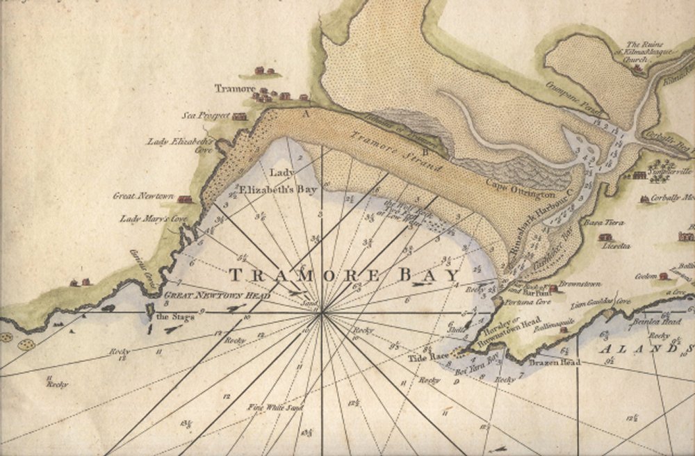
The discovery of this relatively intact vessel on a flat section of shoreline with no known navigation hazards nearby appeared to be an enigma. It was not until investigations of historic maps of Tramore Bay was undertaken that the apparent cause of the stranding became apparent. During our cartographic search, a navigation chart of Tramore Bay produced by Laurie and Whittle in the 1790’s was found. This map recorded depth soundings, navigation hazards and seabed form for the Bay as well as provided advice to mariners. Concerning Tramore Bay, there was a small paragraph entitled Observations on Tramore Bay. This paragraph detailed how many vessels mistook Tramore Bay for Waterford Estuary and were grounded in shallows on the northeastern side of the Bay. The observations then advised mariners on manoeuvres to avoid such grounding. These involved turning their ship towards Tramore town and running their vessel ashore, it was then reported that the subsequent tide could refloat the vessel and allow it to return to safety.

Extract from above mentioned map showing Tramore Bay
The content of these advice notes appeared to indicate an apparent cause of the stranding of our vessel. Had the vessel mistook Tramore Bay for Waterford Estuary, did it progress towards the eastern side of the the bay only to discover that they were in the wrong location? Were this the case then the ships master would certainly have known to drop his anchors, spin his ship 90° and head towards the beach at Tramore. Although our investigations of the vessel are not fully completed, it would appear that based on the current orientation, location, state and nature, our vessel was indeed one of the tragedies where the vessel was run onto the shore in order to ensure safety only to become stranded and later abandoned.
Studies of the wreck are still ongoing and it is hoped that through these studies, a name, date and origin of this vessel can be determined.

Investigations complete
This entry was posted on Monday, April 14th, 2008 at 3:25 pm. It is filed under About Marine, Papers & Reports and tagged with Ireland, shipwrecks, tramore, Underwater Archaeology, Wreck.
You can follow any responses to this entry through the RSS 2.0 feed.


I am intrested to know if you ever did Identify the ship on the beach??
Not yet Eddie. Will keep the blog updated when and if we can succesfully identify the wreck..
Declan
There were several wooden vessels exposed on the beach at Tramore in the aftermath of a storm around 1989. My dad took some photos which I have uploaded to Flickr, heres the link for that,
http://www.flickr.com/photos/33577523@N08/sets/72157631438567374/
Thanks Paul – Great photo’s… I’ll point it out to Eoghan at Moore Marine.
Declan
4th March 2014. Six shipwrecks presently exposed on Tramore Beach and clearly viewable at low tide only. Has anyone, or any website, got details of names of ships wrecked? I have a set of photos available to any genuinely interested party. harryreid@live.ie +353 (0)87 8138330. A relief of Tramore Bay, listing some of the wreck names and dates lost, can be viewed in the Coastguard Cultural Centre in Tramore.
Once again the wrecks have become visible, I know a website which lists all the known wrecks even down to ship type, I believe some of wrecks to be brought up to shore unloaded and left some could have been foundered too, among the ship types your looking at Smacks, sloops and brigs if they are 1780 to 1820 wrecks which is quite probable, Tramore also had quite the little fishing business and used Rhine Shark Harbour to moor until the boatstrand was constructed, the bay its self was extremely hazardous to ships.